English: España / Espanya / Espainiako (Spain) Maps showing all or most of the territory (geographic area) of modern-day Spain - as the lands were in the 8th century (701-800 CE)
Español: Mapas que muestran todo o la mayor parte del territorio (el área geográfica) de la España actual (Spain) - como eran las tierras en el siglo X (701-800 EC)
Català: Mapes que mostren tot o la major part del territori (l'àrea geogràfica) de l'Espanya actual (Spain) - com eren les terres al segle X (701-800 EC)
Euskara: Gaur egungo Espainiako (Spain) lurralde osoa edo gehiena (hau da, eremu geografiloa) erakusten duten mapak da X. mendean (701-800 K.o.) lurrak ziren bezala
See Wikimedia Commons Atlas of Spain for a general overview of the territory including its evolution in European history.
Additional maps related to the history of Spain (including larger entities comprising or controlling the territory, smaller entities within the territory, and colonial territories) can be found at Maps of the history of Spain.


 Spain - as the lands were in the 8th century (701-800 CE)
_The_Iberian_peninsula_531-711.jpg/120px-(Spruner-Menke%2C_map_14)_The_Iberian_peninsula_531-711.jpg) (Spruner-Menke, map 14) The Iberian peninsula 531-711.jpg 3,355 × 2,759; 2.18 MB
(Spruner-Menke, map 14) The Iberian peninsula 531-711.jpg 3,355 × 2,759; 2.18 MB.jpg/120px-Hispania_visigoda_(625-711).jpg) Hispania visigoda (625-711).jpg 1,091 × 900; 191 KB
Hispania visigoda (625-711).jpg 1,091 × 900; 191 KB Hispania visigoda del 625 al 711.jpg 1,962 × 1,536; 1.18 MB
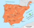 Iberia 700-es.svg 924 × 762; 710 KB
 Iberia 700.svg 924 × 762; 314 KB
 Visigothic Kingdom 586-711 be.svg 1,263 × 1,053; 1.39 MB
 Visigothic Kingdom 586-711 es.svg 1,246 × 975; 1.09 MB
 Visigothic Kingdom 586-711 pt.svg 1,246 × 975; 401 KB
 Visigothic Kingdom 586-711 ru.svg 1,263 × 1,053; 1.39 MB
 Péninsule Ibérique en 711.png 2,000 × 1,557; 790 KB
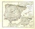 Spruner-Menke Handatlas 1880 Karte 15.jpg 3,599 × 2,995; 1.32 MB
.jpg/120px-thumbnail.jpg)
 Al-Andalus-711.svg 294 × 234; 159 KB
 Al-Andalus-711-end.svg 294 × 234; 172 KB
 Al-Andalus-712.svg 294 × 234; 179 KB
 Invasionislámicaespaña.svg 673 × 692; 1.51 MB
 Al-Andalus-713.svg 294 × 234; 179 KB
 Al-Andalus-714.svg 294 × 234; 172 KB
 Al-Andalus-716.svg 294 × 234; 174 KB
 Al-Andalus-719.svg 294 × 234; 170 KB
 Al-Andalus-724.svg 294 × 234; 171 KB
 Al-Andalus732 fr.svg 863 × 717; 712 KB
 Al-Andalus732-ar.jpg 349 × 327; 30 KB
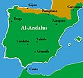 Al-Andalus732.jpg 349 × 327; 21 KB
 Al-Andalus732.svg 863 × 717; 814 KB
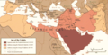 Age of Caliphs.png 684 × 347; 59 KB
 Califate 750.jpg 1,492 × 1,248; 494 KB
 Caliphate 750-es.svg 3,592 × 1,920; 1.62 MB
 Caliphate 750-hu.svg 3,592 × 1,920; 80 KB
 Caliphate 750-pt.svg 512 × 273; 53 KB
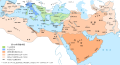 Caliphate 750-zh.svg 4,490 × 2,400; 392 KB
 Caliphate 750.jpg 1,000 × 834; 185 KB
 Péninsule Ibérique en 757.png 2,000 × 1,500; 722 KB
 España750.jpg 600 × 562; 224 KB
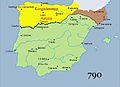 Reino de Asturias.jpg 424 × 306; 22 KB
_The_Iberian_peninsula_531-711.jpg)
.jpg)


.jpg)


